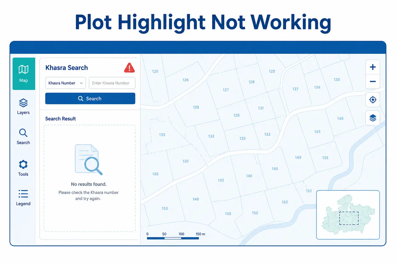
Plot Highlight Problem
Khasra search या plot highlight काम न करे तो format, Village और parcel data checks।
View Plot Highlight Fixes→ Menu
MenuWebGIS MP Bhulekh से Plot Boundary और Land Map समझें
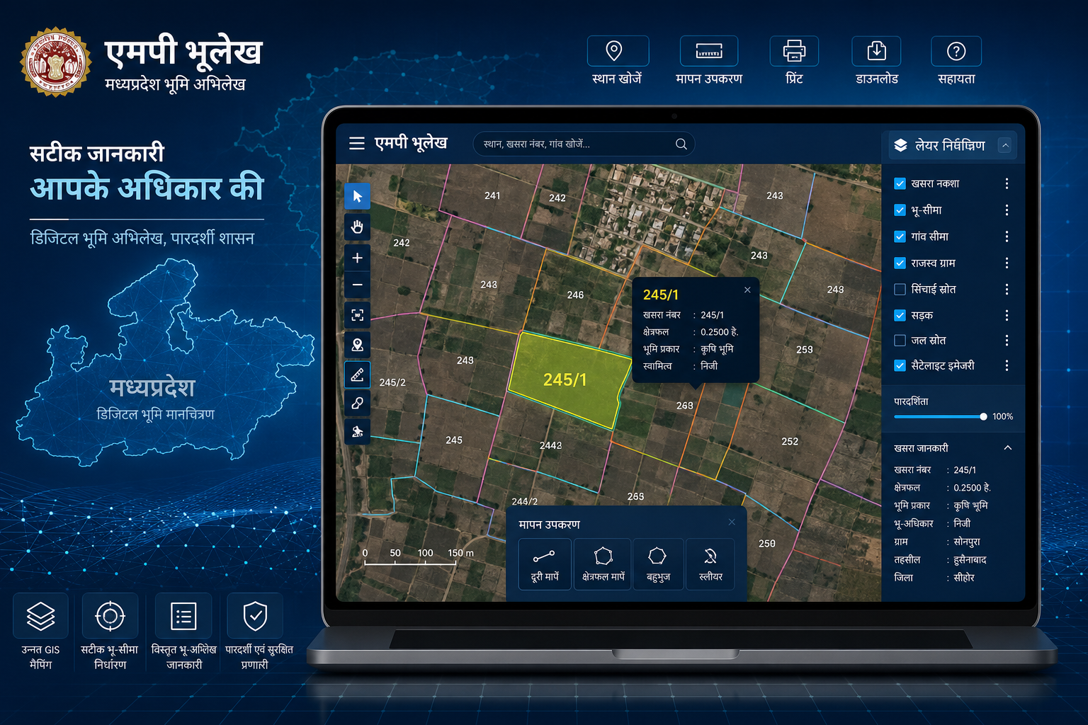
WebGIS MP Bhulekh एक interactive GIS-based map system है, जिसकी मदद से उपलब्ध data के अनुसार किसी Village का land layout, Khasra parcel, आसपास के plots, map layers और plot की visual boundary देखी जा सकती है।
यह सामान्य MP Bhulekh Naksha की तुलना में अधिक interactive experience दे सकता है, लेकिन इसकी उपलब्धता और features हर District, Tehsil तथा Village में समान होना जरूरी नहीं है।
इस complete guide में आप जानेंगे:
Plot search शुरू करने से पहले Owner Name, Khasra Number और Area verify करने के लिए MP Bhulekh Khasra Khatauni guide देखें।
महत्वपूर्ण सूचना: MPBhulekh.app एक स्वतंत्र informational website है। यह Madhya Pradesh Government, Revenue Department या किसी official land-record portal से affiliated नहीं है। उपलब्ध online map को सामान्य reference के रूप में देखें। Exact boundary, ownership, encroachment, registry या legal dispute के लिए certified records, official survey और संबंधित revenue authority से verification जरूरी हो सकता है।
सामान्य प्रक्रिया इस प्रकार हो सकती है:
Official land-map service खोलें → District चुनें → Tehsil चुनें → Village select करें → Khasra Number search करें → Plot highlight या map parcel देखें → Layers और zoom controls का उपयोग करें → Khasra record से details compare करें
Portal interface, search filters और available map layers समय, location और service version के अनुसार अलग हो सकती हैं।
नीचे दिए गए links से सीधे संबंधित section पर जा सकते हैं।
WebGIS MP Bhulekh एक web-based Geographic Information System है। यह land-related spatial information को interactive digital map पर दिखाने का माध्यम हो सकता है।
Simple language में:
जमीन का text-based record दिखाती है।
Village या plot का basic visual map दिखा सकता है।
Interactive map के साथ plot parcels, layers, labels, boundaries और geographic features समझने में मदद कर सकता है।
लोग इस service को इन नामों से भी search करते हैं:
इन सभी searches का मुख्य उद्देश्य जमीन की visual location, Khasra parcel या plot boundary का शुरुआती idea प्राप्त करना होता है।
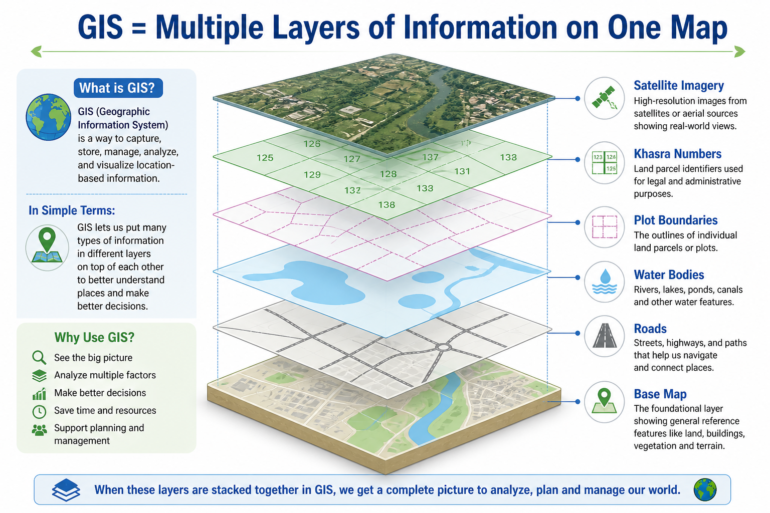
GIS का full form है: Geographic Information System
यह ऐसी mapping technology है जिसमें अलग-अलग प्रकार की location-based information को एक digital map पर layers के रूप में दिखाया जाता है।
उदाहरण के लिए, एक WebGIS map में अलग-अलग layers हो सकती हैं:
मान लीजिए किसी Village का एक basic नक्शा है। उसके ऊपर:
इन सभी layers को एक interactive map पर देखना GIS system का basic example है।
केवल एक स्थिर picture हो सकता है।
अपनी जमीन की approximate map location और आसपास के plots समझने के लिए।
Agricultural plot, आसपास के fields, road और canal जैसी available map details देखने के लिए।
Seller द्वारा बताए गए plot और Khasra Number की शुरुआती map verification के लिए।
Buyer को plot की approximate location समझाने के लिए।
Inherited या jointly owned property का visual layout समझने के लिए।
Initial map reference और document comparison के लिए।
Official survey request से पहले available online records और plot layout समझने के लिए।
Available data के अनुसार GIS land map में निम्न information दिखाई दे सकती है:
हर Village का GIS data एक ही समय पर digitize या update नहीं होता।
Interactive map को final legal verification tool नहीं मानना चाहिए। यह अकेले निम्न बातें verify नहीं करता:
| Feature | MP Bhulekh Naksha | WebGIS MP Bhulekh |
|---|---|---|
| Main Purpose | Basic Village या plot map | Interactive GIS-based land map |
| Map Type | Simple visual map | Dynamic spatial map |
| Plot Boundary | Basic lines | अधिक interactive display हो सकता है |
| Khasra Search | Limited या location-dependent | उपलब्धता के अनुसार advanced search |
| Layers | सीमित | Multiple layers हो सकती हैं |
| Plot Highlight | Limited | Search के बाद available हो सकता है |
| Zoom Control | Basic | अधिक detailed zoom |
| Overlay | Limited | Khasra या parcel overlay उपलब्ध हो सकता है |
| Satellite Base | सामान्यतः limited | कुछ versions में available |
| Nearby Plot Comparison | Basic | अधिक practical हो सकता है |
| Mobile Performance | अपेक्षाकृत सरल | Heavy होने के कारण slow हो सकता है |
| Legal Proof | नहीं | नहीं |
| Best Use | Basic map understanding | Detailed visual analysis |
आमतौर पर निम्न information उपयोगी होती है:
Khasra Number नहीं मालूम? पहले Khasra Number Kaise Nikale MP पढ़ें। Owner Name से record search करने के लिए MP Bhulekh Owner Name Search guide देखें।
Portal interface अलग हो सकता है, लेकिन सामान्य process इस प्रकार है।
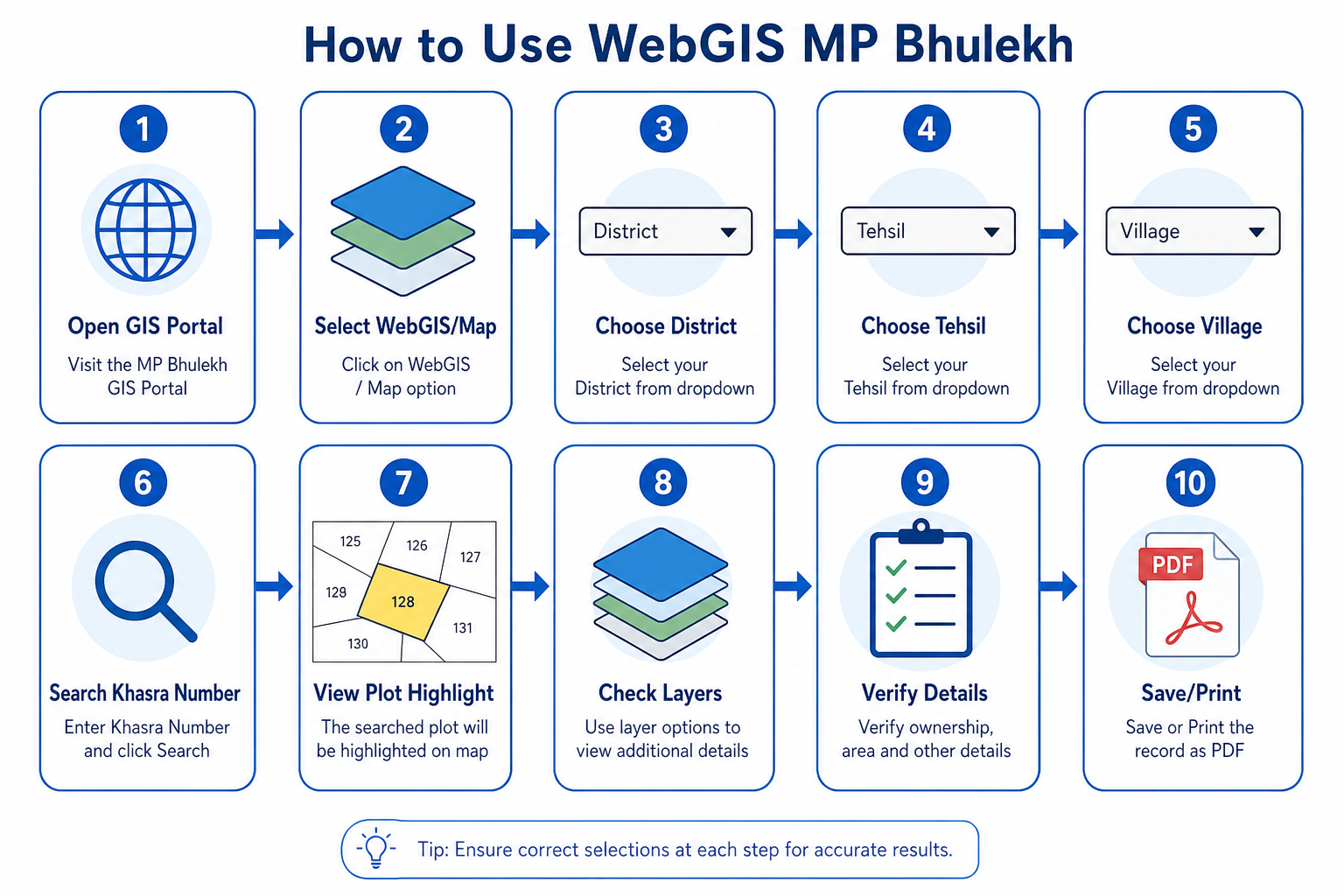
Official Madhya Pradesh land-record या संबंधित government GIS service खोलें। URL खोलते समय domain और security carefully check करें। Unknown websites पर Aadhaar Number, OTP, Bank details, Registry copy या Personal identity document share न करें।
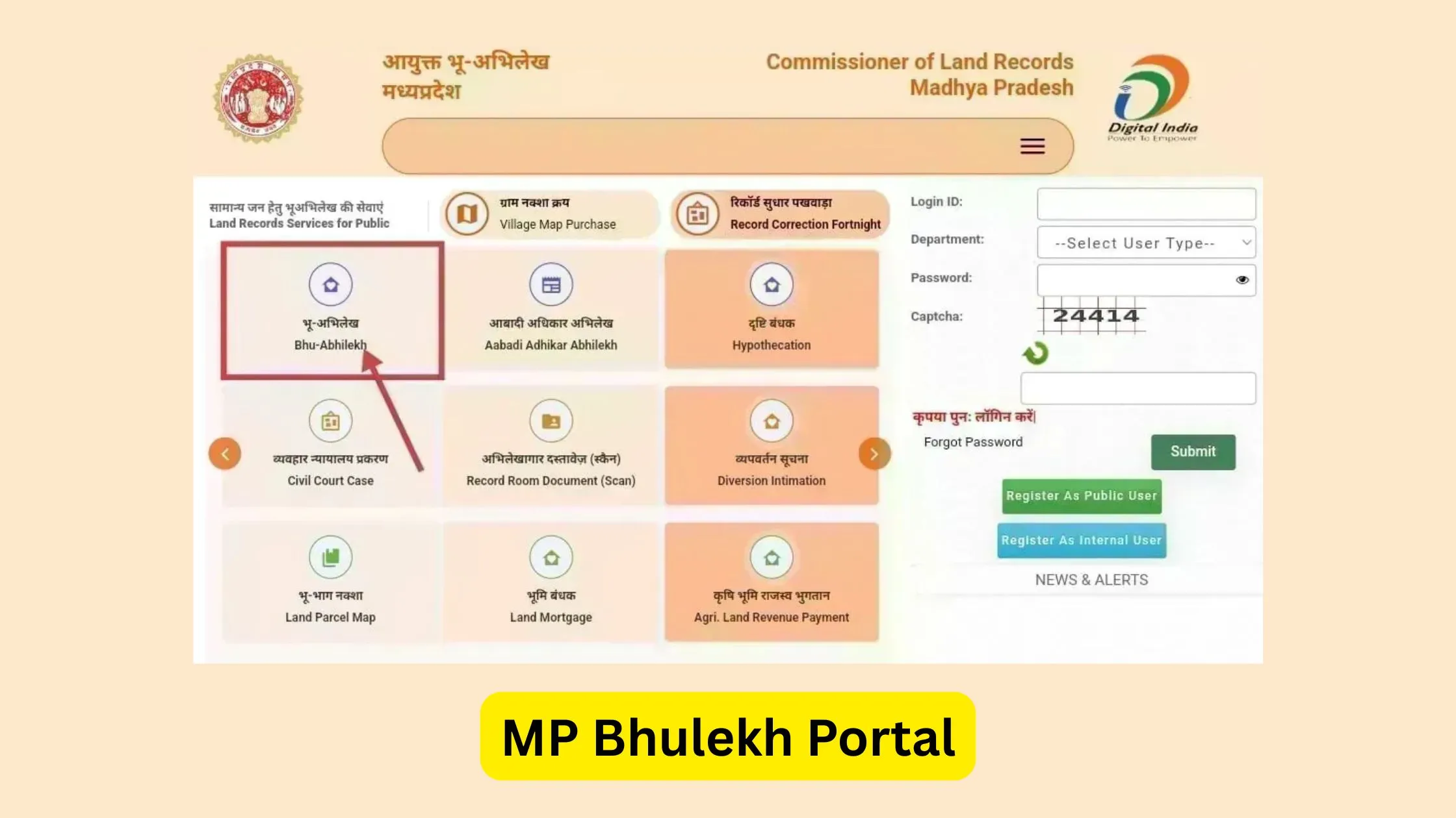
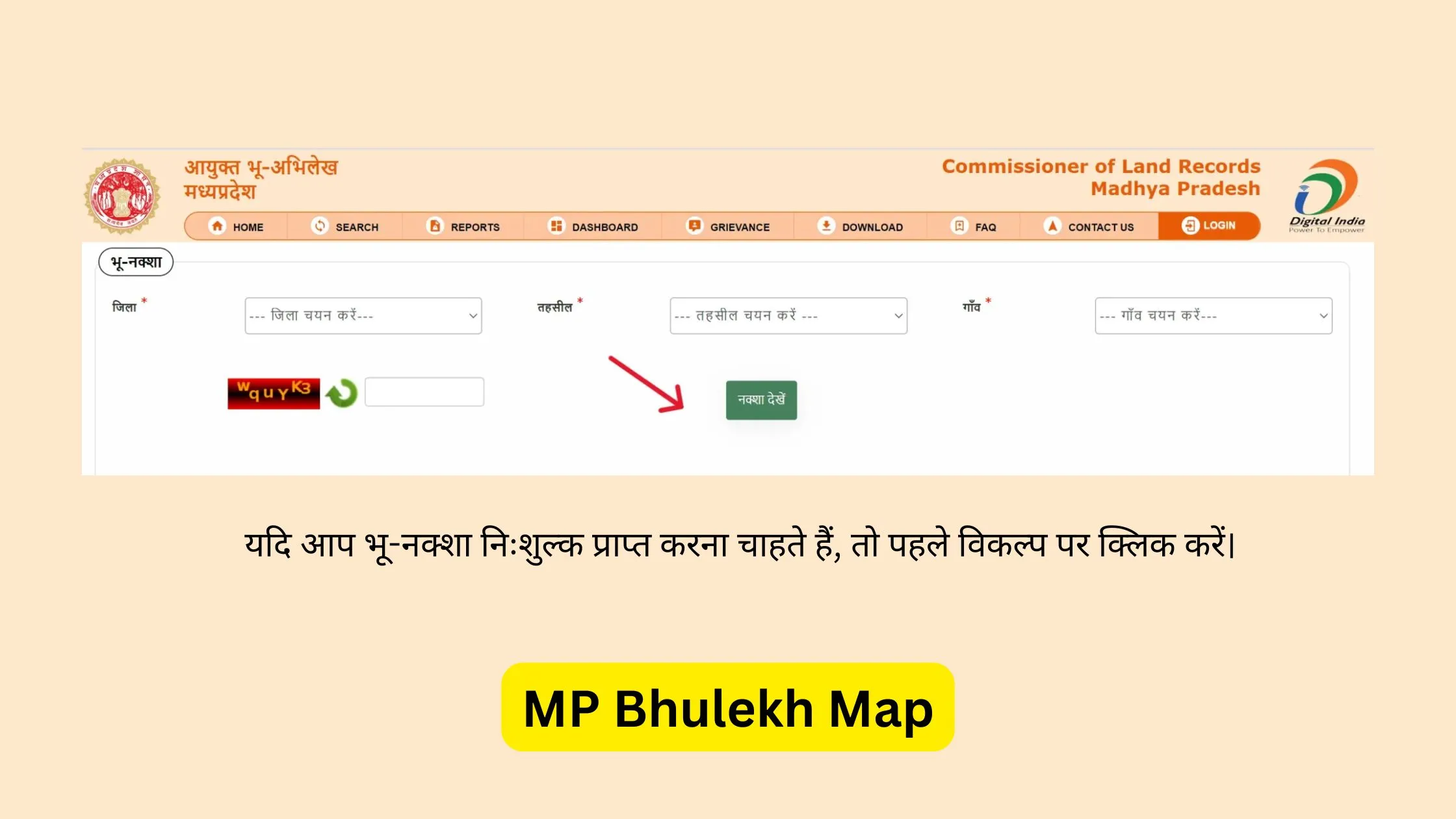
Service WebGIS, GIS Map, Land Parcel Map, Bhu Naksha, Plot Map, भू-नक्शा, Land Map, Map View या Spatial Map जैसे नाम से दिखाई दे सकती है।
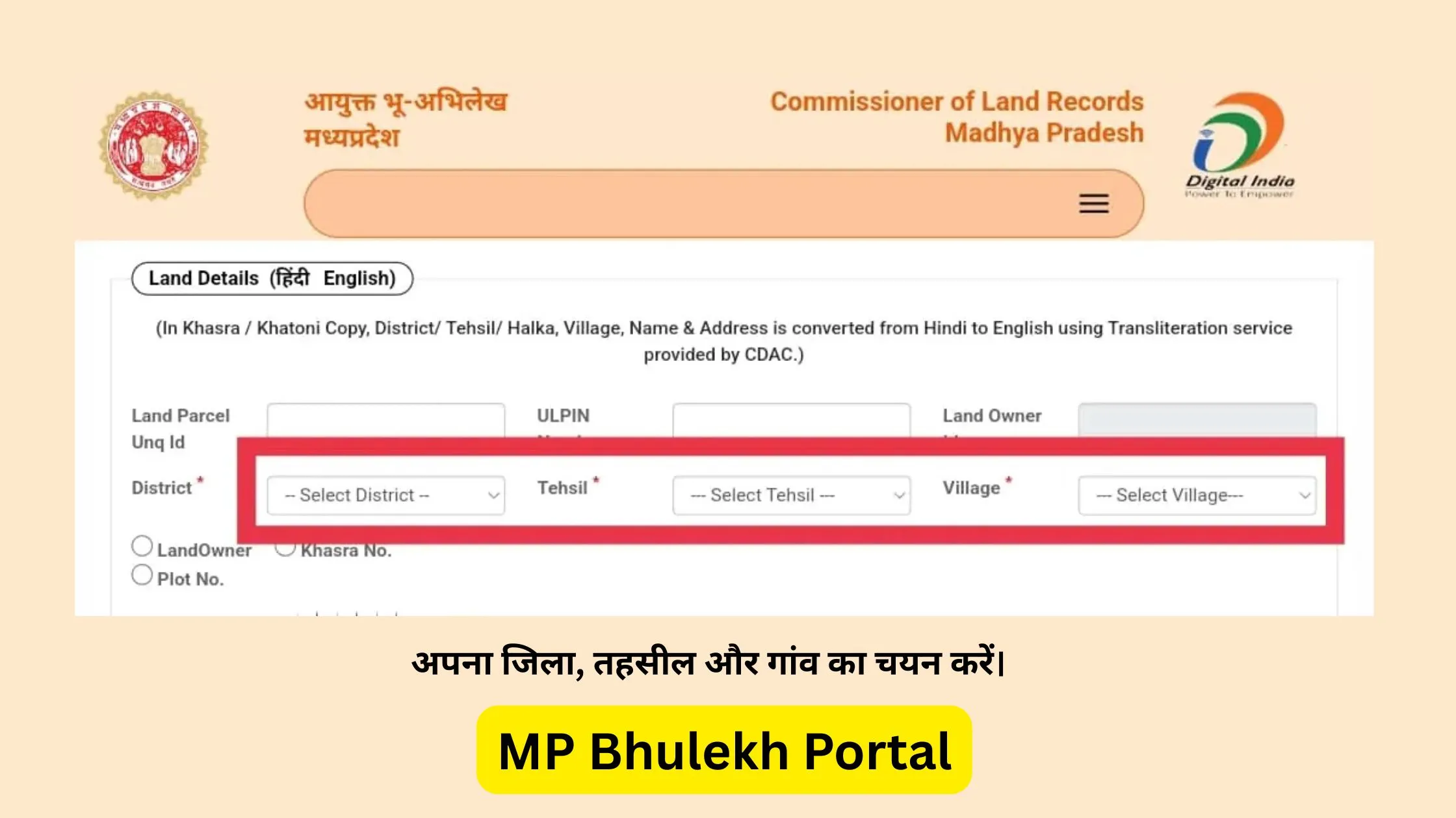
जिस District में जमीन स्थित है, वही option चुनें। गलत District select करने पर आगे की Tehsil और Village list भी गलत होगी।
District select करने के बाद सही Tehsil चुनें। List तुरंत load न हो तो कुछ समय wait करें, page refresh करें, District दोबारा select करें या browser बदलें।
Village selection सबसे critical step है। कई Villages के नाम एक जैसे हो सकते हैं। District, Tehsil, Patwari Halka (यदि उपलब्ध हो), Village spelling और Registry में दिया location verify करें।
Map interface में Search, Find Plot, Khasra Search, Parcel Search, Plot Number, Survey Number, Query या Identify जैसे options खोजें।
उदाहरण: 125, 125/1, 125/2, 78/3, 125 Min या 125 Part। Registry या current land record में जो format है, उसी format से search करें।
Search successful होने पर Plot color change हो सकता है, Boundary highlight हो सकती है, Map selected parcel पर zoom कर सकता है या Side panel में details दिखाई दे सकती हैं।
आसपास के Khasra Numbers, Plot shape, Road, Canal, Water body, Village boundary, Seller द्वारा बताई location और Registry description compare करें।
Layers panel उपलब्ध हो तो relevant options on या off करें।
Owner Name, Khasra Number, Area, Village, Tehsil, Mutation status और Land classification को Khasra Khatauni से compare करें।
Available options के अनुसार Print, Save as PDF, Screenshot, Export Map या Share Map use कर सकते हैं। Saved map certified copy नहीं मानी जाती।
Record details compare करने के लिए MP Bhulekh Khasra Khatauni guide पढ़ें।
Specific plot search के लिए Khasra Number सबसे helpful है, लेकिन unavailable होने पर निम्न methods उपयोगी हो सकते हैं।
Owner या Khatedar Name से land record खोजकर Khasra Number प्राप्त करें। MP Bhulekh Owner Name Search
Khata या Khatauni में संबंधित Khasra Numbers मिल सकते हैं। MP Bhulekh Khasra Khatauni
Registry document में Village, Khasra Number और Area दिया हो सकता है।
पुराने या available revenue records से Khasra details मिल सकती हैं। B-1 Rin Pustika MP
Nearby road, canal, Village boundary या known Khasra के आधार पर approximate area locate किया जा सकता है। Manual search final legal verification नहीं है।
Layer digital map पर information की अलग category होती है। User available options के अनुसार layer on या off कर सकता है।
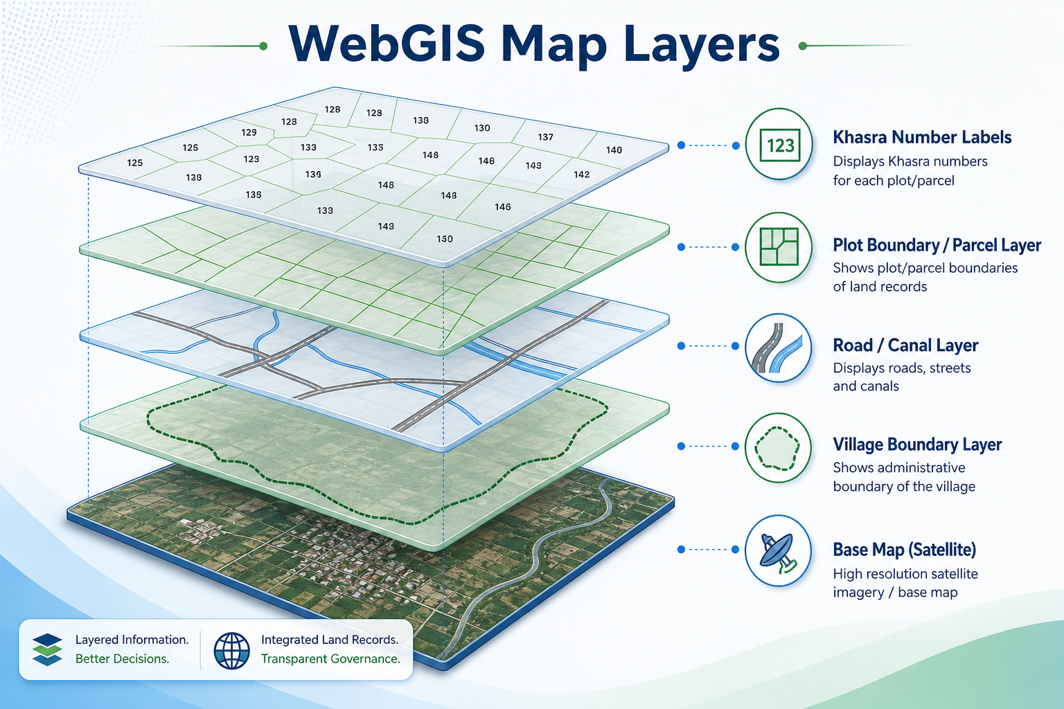
Individual land parcels और उनकी boundaries दिखा सकती है।
Plot के ऊपर Khasra Number display कर सकती है।
Village की administrative limit दिखा सकती है।
Available data के अनुसार roads या paths दिखा सकती है।
Irrigation canal या water channel display कर सकती है।
Pond, river, lake या अन्य water feature दिखा सकती है।
Available classification के अनुसार public या government land mark कर सकती है।
District, Tehsil, Village या अन्य boundaries दिखा सकती है।
Map का background होता है।
Satellite-style imagery या aerial background दिखा सकती है।
Village, road, plot और अन्य names display कर सकती है।
Overlay का अर्थ है किसी base map के ऊपर additional information दिखाना। उदाहरण: Satellite image के ऊपर Khasra boundaries दिखाई जाएं, तो Khasra boundary एक overlay है।
Common overlays:
Fix:
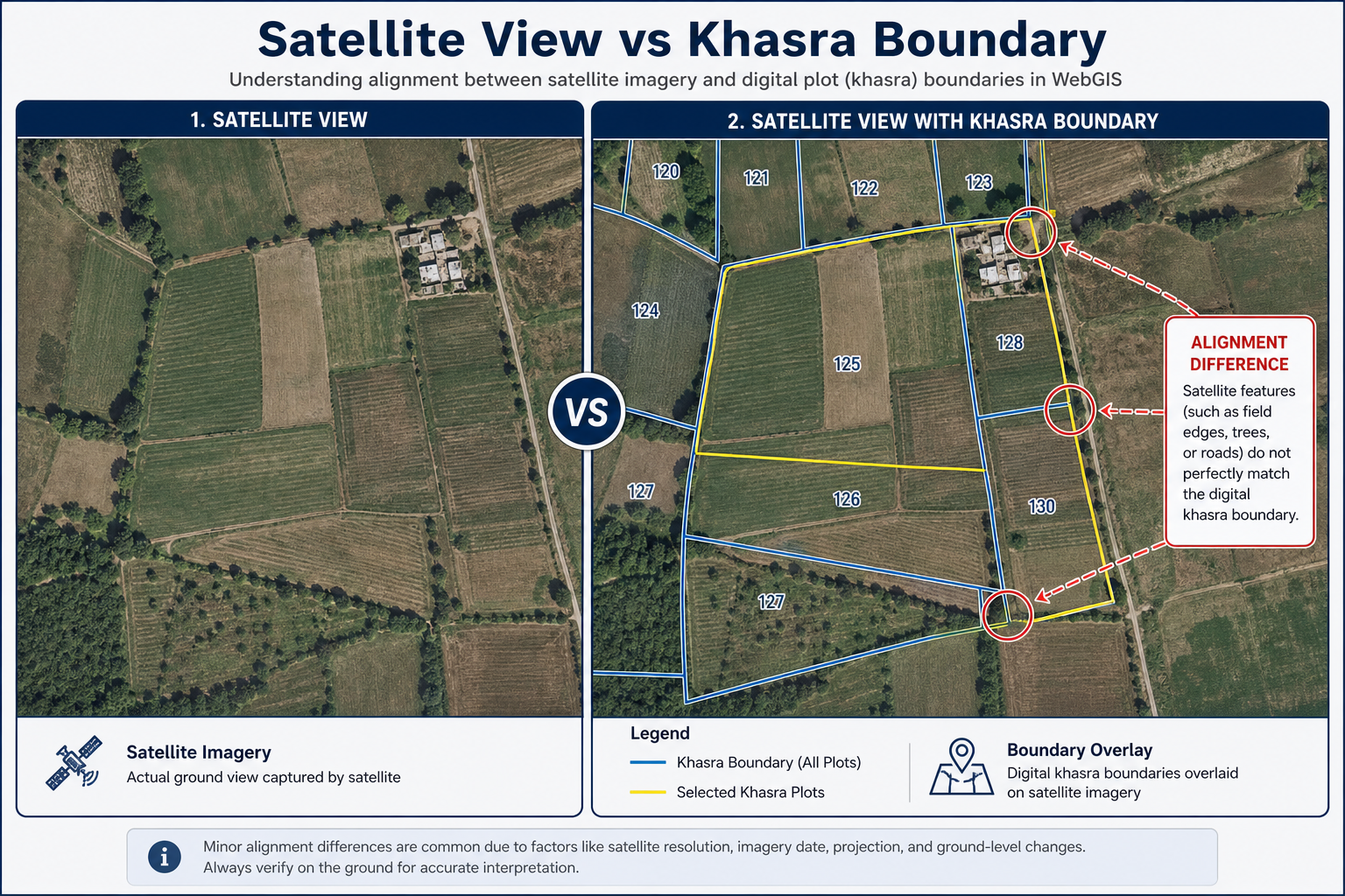
Satellite view जमीन के area का imagery-based visual background दिखा सकता है। इससे user को plot के आसपास का real-world visual context समझने में मदद मिल सकती है।
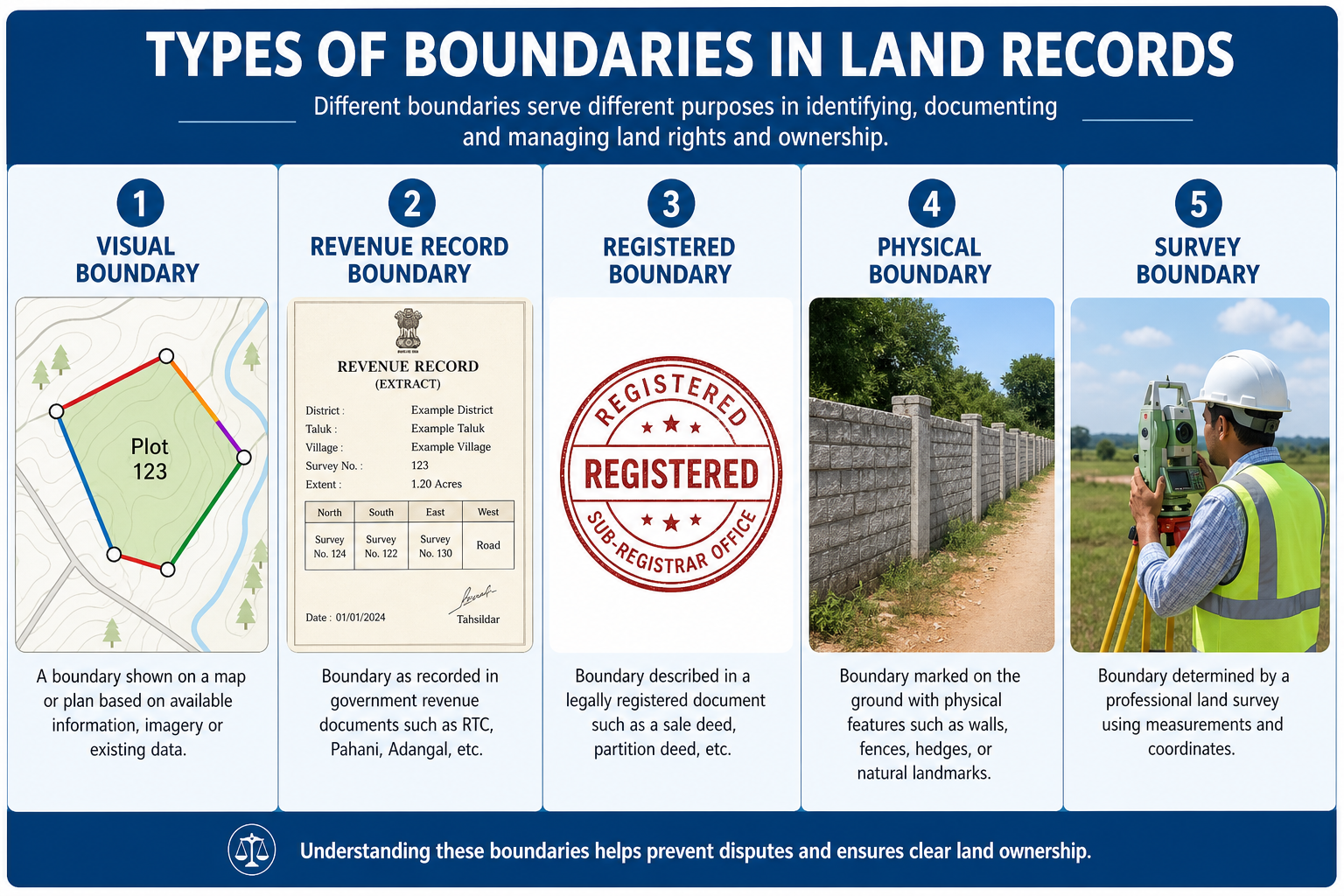
Map पर visible boundary एक digital parcel line हो सकती है। यह जमीन पर दीवार, fencing, पत्थर या actual survey mark के साथ exactly match करना जरूरी नहीं है।
Online map पर दिखाई देने वाली plot line।
Revenue map और official land record में recorded parcel boundary।
Registry या sale deed में वर्णित property boundary।
Ground पर दिखाई देने वाली fencing, wall, road, tree line या landmark।
Official measurement और survey process से निर्धारित boundary।
Serious difference होने पर wrong plot और boundary mismatch checklist देखें। Exact ground सीमा या dispute के लिए online boundary और official survey का अंतर समझें। Record error suspect हो तो MP Bhulekh Record Correction guide देखें और संबंधित authority से official verification लें।
Search के बाद selected Khasra parcel:
अगर Khasra Number enter करने के बाद भी plot highlight नहीं होता, तो सबसे पहले complete Khasra format (जैसे 125/2), सही Village/Tehsil, subdivision और GIS parcel data availability verify करें। Search tool active होने के बाद ही Identify या Find Plot use करें। Wrong parcel highlight होने पर nearby Khasra Numbers, Area और Owner Name compare करें।
Detailed troubleshooting के लिए plot highlight problem का समाधान पढ़ें।
Highlight केवल selected map parcel दिखाता है।
Plot को closer view में देखने के लिए।
Village और आसपास का wider area देखने के लिए।
Map को अलग direction में move करने के लिए।
Selected parcel की available information देखने के लिए।
Khasra या plot locate करने के लिए।
Different map layers on/off करने के लिए।
Colors, symbols और line types समझने के लिए।
Initial map view पर लौटने के लिए।
Larger viewing area प्राप्त करने के लिए।
Approximate distance या area measurement available हो सकता है। ऐसी measurement को official survey न मानें।
Visible map को print या save करने के लिए।
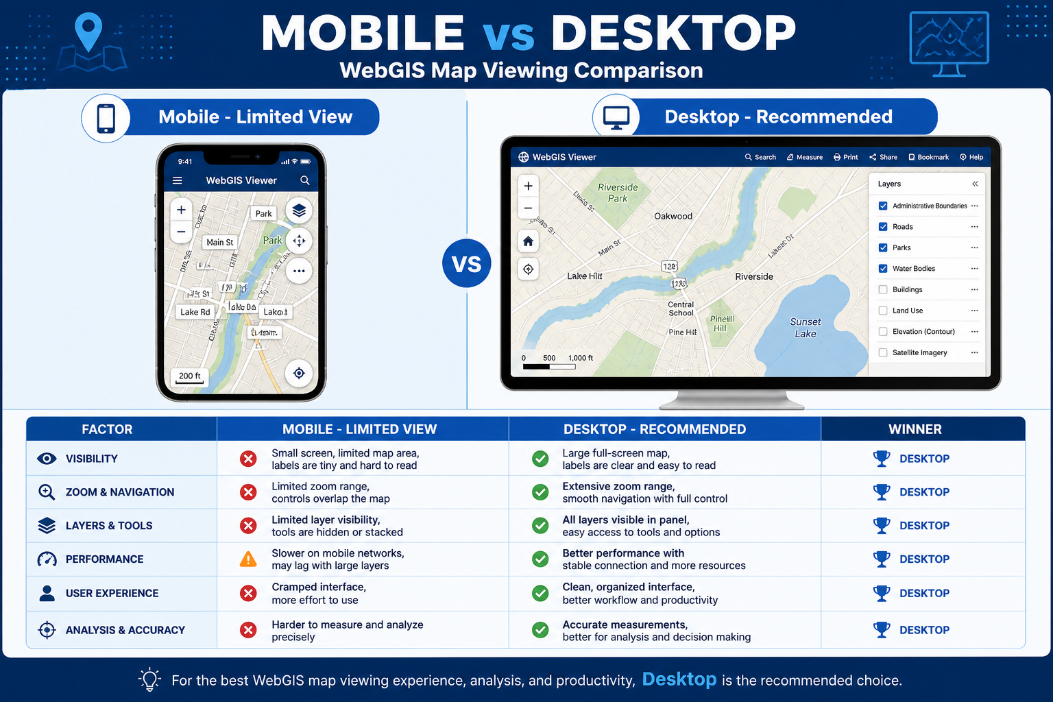
| Factor | Mobile | Desktop/Laptop |
|---|---|---|
| Map Visibility | सीमित | बेहतर |
| Zoom Control | कठिन हो सकता है | आसान |
| Layer Panel | Overlap हो सकता है | Clear |
| Khasra Labels | छोटे | अधिक readable |
| Browser Memory | सीमित | अधिक |
| Print Option | Limited | बेहतर |
| Multiple Layers | Slow हो सकती हैं | अधिक stable |
| Recommended Use | Quick check | Detailed map analysis |
WebGIS normal webpage से ज्यादा browser resources use कर सकता है। नीचे common problems और solutions दिए गए हैं।
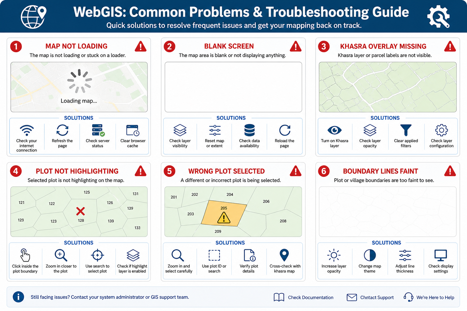
Possible reasons:
Solutions:
Detailed help: MP Bhulekh Not Working
Possible reasons:
Solutions:
Detailed help: MP Bhulekh Map Blank Solution
Possible reasons:
Solutions:
Detailed help: Khasra Overlay और Map Layers
Possible reasons:
Solutions:
Detailed help: Plot Highlight Problem का समाधान
Possible reasons:
Solutions:
Detailed help: Wrong Plot और Boundary Mismatch
Possible reasons:
Solutions:
Detailed help: Khasra Overlay और Map Layers
Possible reasons:
Solutions:
WebGIS केवल शुरुआती verification का हिस्सा होना चाहिए।
Buyer Checklist:
Farmers WebGIS में available data के अनुसार देख सकते हैं:
Agriculture loan, insurance, subsidy या government scheme के लिए required documents अलग हो सकते हैं। संबंधित authority से current requirements verify करें।
WebGIS dispute को final रूप से solve नहीं करता।
यह निम्न कामों में मदद कर सकता है:
Final Resolution के लिए क्या चाहिए हो सकता है?
| Feature | WebGIS Boundary | Official Survey / Demarcation |
|---|---|---|
| Purpose | Online visual reference | Ground-level official measurement |
| Access | Online | Application या authority process |
| Plot Layout | Digital | Physical measurement |
| Accuracy Use | Initial understanding | Official verification |
| Boundary Marks | नहीं | Ground points mark किए जा सकते हैं |
| Legal Use | सीमित | Issuing process पर निर्भर |
| Encroachment Check | Confirm नहीं करता | Ground verification संभव |
| Cost | Basic view free हो सकता है | Fee लग सकती है |
| Time | तुरंत access हो सकता है | Process authority पर निर्भर |
Property या ownership related काम में सिर्फ interactive map पर निर्भर न रहें। यह practical sequence उपयोगी हो सकती है।
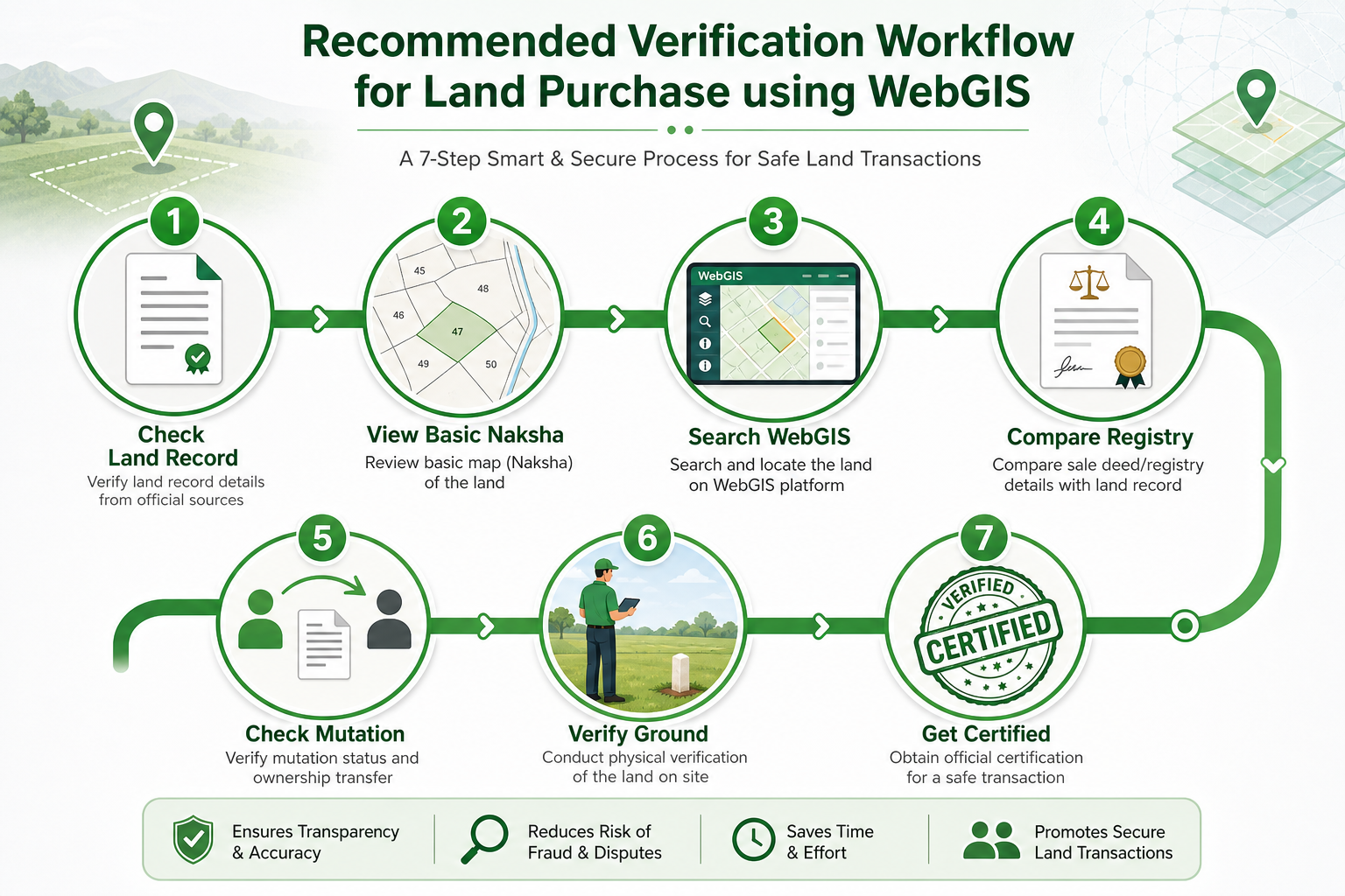
MP Bhulekh Khasra Khatauni से Owner Name, Area और Khasra verify करें।
Khasra Khatauni Guide→Khasra search, plot boundary और available layers देखें।
Village, Khasra, Area और boundary description compare करें।
Ownership change हुआ है तो mutation record देखें।
MP Bhulekh Mutation Naamantaran→Seller, neighboring plots, road और actual possession check करें।
High-value transaction, dispute या boundary issue में official survey, certified map और professional verification लें।
Understand Certified Verification→Similar names के कारण wrong map load हो सकता है।
Owner, Area और Registry भी verify करें।
WebGIS visual reference है।
Imagery और parcel lines में alignment difference हो सकता है।
Screenshot official certified document नहीं है।
Legal right of way अलग verification मांग सकता है।
Subdivision या record update के कारण current Khasra अलग हो सकता है।
Map slow या unclear हो सकता है।
Fake land-record websites से बचें।
Map देखने के नाम पर कोई unknown व्यक्ति OTP मांगे तो share न करें।
Advertisement को official download button न समझें।
Unverified developer की land-record app को unnecessary permissions न दें।
Private website government map direct update नहीं कर सकती।
Payment केवल verified official service या authorized channel पर करें।
Registry, Aadhaar और land documents unknown WhatsApp number पर share न करें।
आगे की जानकारी के लिए ये related guides उपयोगी हो सकती हैं।
Khasra search या plot highlight काम न करे तो format, Village और parcel data checks।
View Plot Highlight Fixes→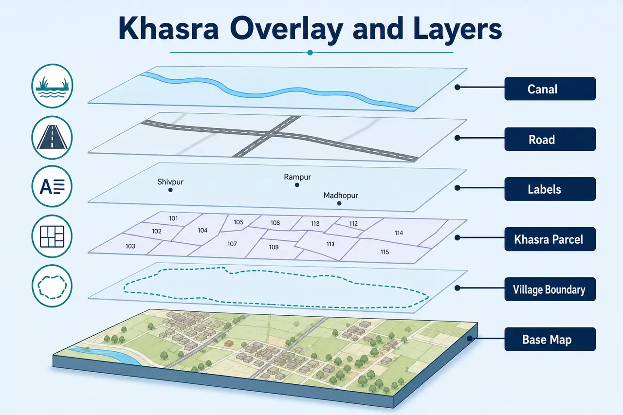
Parcel layer, labels, Village boundary और faint overlay कैसे समझें।
Understand Khasra Layers→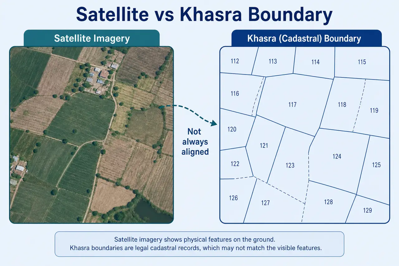
Satellite imagery और digital parcel line में alignment difference समझें।
Compare Satellite and Boundary→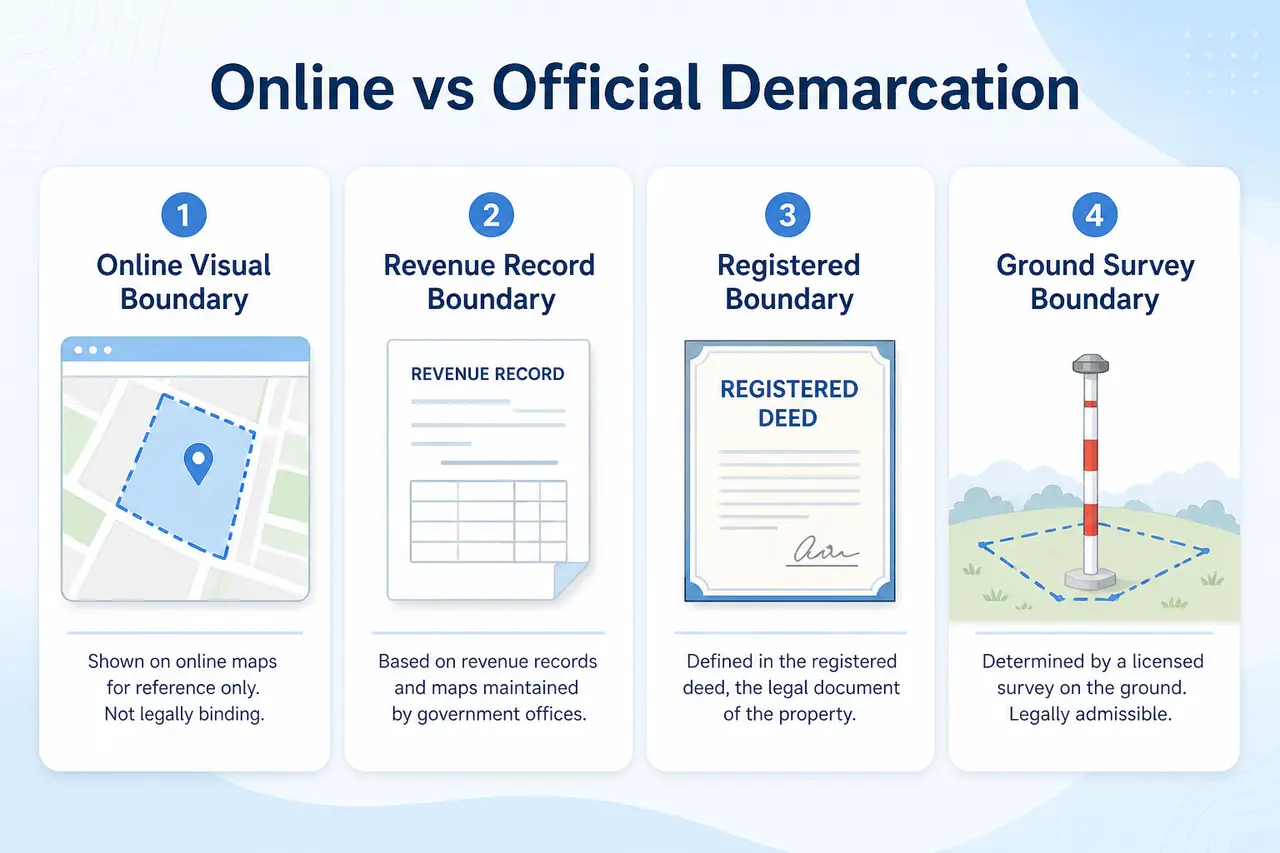
Online boundary और official survey/demarcation कब जरूरी है।
Learn When Official Verification Is Needed→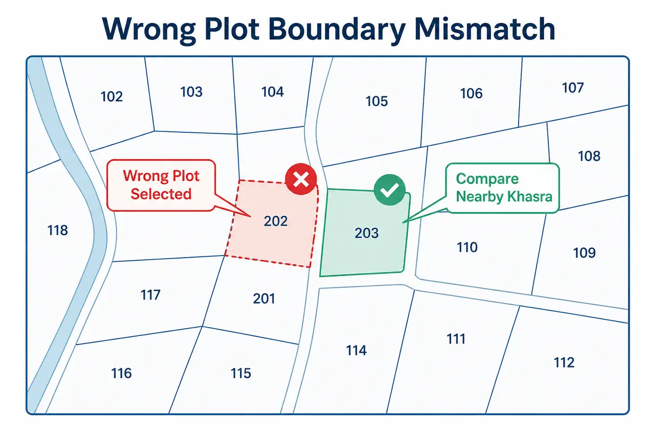
Map, registry या ground boundary match न हो तो verification steps।
Check Boundary Mismatch Steps→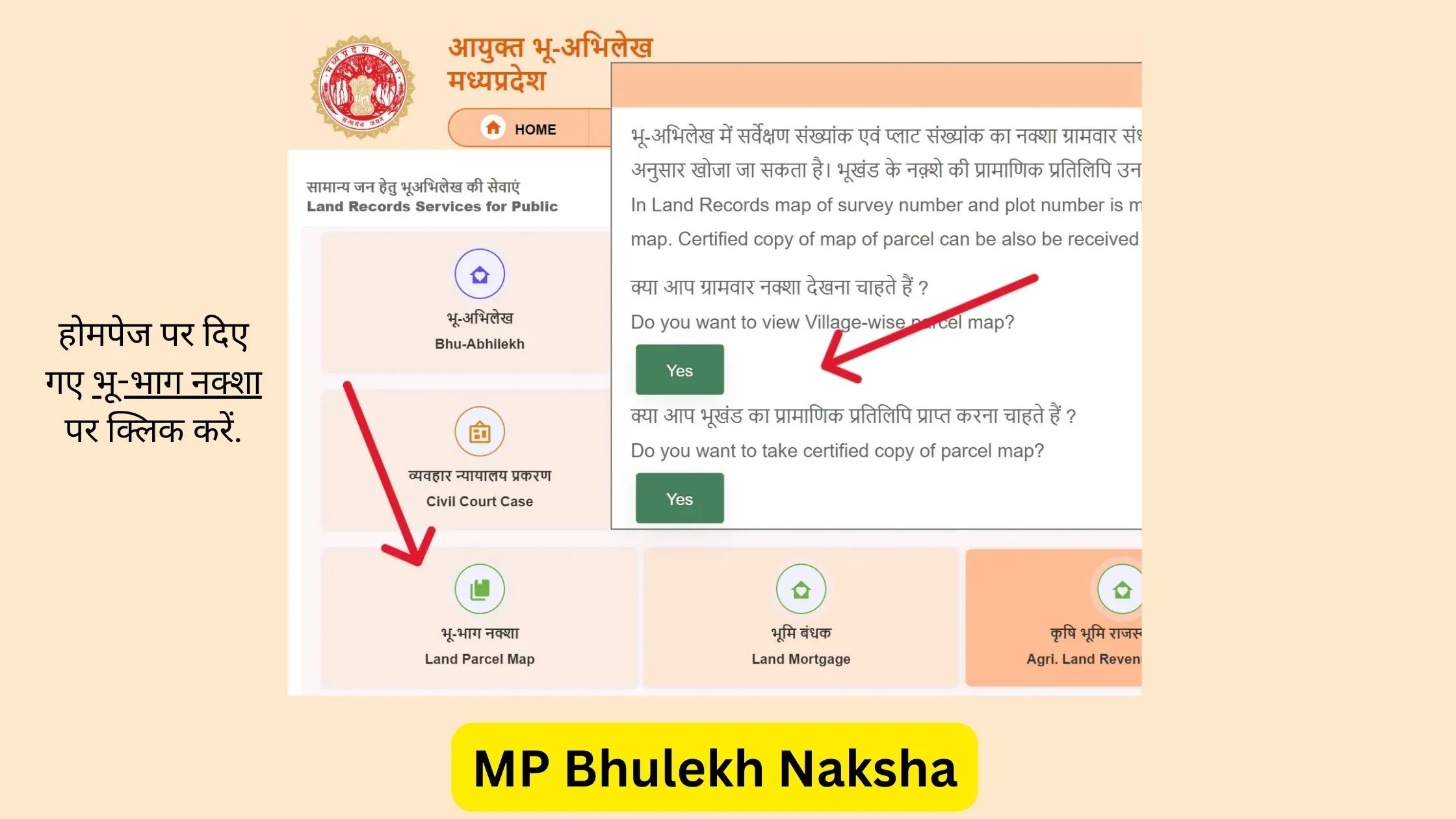
Map और land record में mismatch होने पर correction options समझें।
MP Bhulekh Record Correction→WebGIS, plot boundary, overlay, satellite view और certified survey से जुड़े सामान्य सवाल
WebGIS MP Bhulekh उपलब्ध land-map data को interactive format में समझने के लिए उपयोगी हो सकता है। इससे Khasra parcel, plot layout, nearby land, roads, water features और available map layers का शुरुआती visual reference मिल सकता है।
Specific plot search करने से पहले:
WebGIS visual understanding के लिए useful है, लेकिन ownership, exact boundary, legal road access, possession या dispute status का final proof नहीं है।
ये informational guides हैं — official government WebGIS service नहीं।
Disclaimer: MPBhulekh.app एक private और independent informational website है। यह Madhya Pradesh Government, Revenue Department, MP Online या किसी official WebGIS portal से affiliated नहीं है। इस page की जानकारी सामान्य educational guidance के लिए है। Online map, screenshot या browser PDF को certified legal record न मानें। Property purchase, ownership, registry, boundary dispute, court matter, encroachment या bank-related use के लिए official records और qualified professionals से verification करें।